

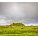
Cairnpapple Hill Panorama
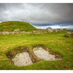
Cairnpapple Hill
Manuel Gloger
Historical Monument
Manuel Gloger
Viewing East
Manuel Gloger
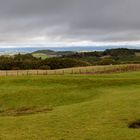
Standing on the roof of the chambered tomb, one has a fantastic view of the glorious Scottish countryside of Midlothian and beyond. The interesting part of the panorama is in the distance and on the horizon. The panorama consists of 19 portrait format photographs and, that as an original TIF file, has a file size of one gigabyte. The half size JPG uploaded is still 29MB. As a result, all details of the background are lost even in a fc full-screen view.
In order to view the details on the horizon lying in the haze of the morning, I recommend following this link to the Zoomify version of the panorama and clicking on the picture several times until the maximum viewing size is reached. Then pan all the way to the west (left) and slowly scroll southeast from there. Zoom out with a click on the Z under the picture. If the image is not fully sharp at first, please click on the image again or wait a moment, as it consists of 675 individual tiles.
http://www.gloger.net/Zoomify_Images/cairnpapple_hill_panorama_w-se.htm
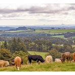
Unfortunately, it was still quite hazy that morning, but those who are familiar with the area can make out prominent landmarks. In the west you first see numerous wind turbines near Harburnhead , that supply the region with oilnatural power. In the middle distance you can see the typical, hilly farmland, with fertile fields and pastures, forests and villages in between. When you discover the western foothills of the "Firth of Forth" estuary, the wind turbine directly to the Cairnpapple Hill appears in the foreground. A little to the left of this is the Grangemouth Oil Refinery to be seen and beyond that the Kinkardine Bridge, set against the Ochil Mountains. Then Cockleroy Hill appears in the middle distance with a farm in front of it, which I also visited that day. Linlithgow hides behind the dense forest with the lone sheep in front.
When the waters of the Firth of Forth reappear in the picture, one soon recognizes a ship lying in Rosyth harbour; maybe the DFS Seaways ferry from Zeebrugge?
The three bridges over the Firth, which are well worth seeing, then appear a little to the east; two road bridges and the Forth (Rail) Bridge, a UNESCO World Heritage Site. In front of it spans the relatively new bridge called Queensferry Crossing, which remembers on Sailings. Only one pillar can be seen from the Forth Road Bridge.
Heading further east, Bass Rock bird island and North Berwick Law hill appear vaguely. Shortly thereafter, the majestic Arthur Seat with the Salisbury Crags appears in the middle of Edinburgh. The view now turns to the Pentland Hills mountain range south of Edinburgh, which is just being illuminated by the sun's rays breaking through the clouds.
This ends the "round trip" through the panorama, estimated at over 300°, which was taken without a tripod. Something sags and the horizon line isn't quite straight. Maybe I'll fix the bug later.
Westlothian: https://en.m.wikipedia.org/wiki/West_Lothian
Harburnhead wind farm: https://maps.app.goo.gl/NBqcVomkgKRdDVfC9
Grangemouth: https://en.m.wikipedia.org/wiki/Grangemouth
Kincardine Bridge: https://en.m.wikipedia.org/wiki/Kincardine_Bridge
Ochil Hills: https://en.m.wikipedia.org/wiki/Ochil_Hills
Cockleroy Hill: https://en.m.wikipedia.org/wiki/Cockleroi
Rosyth - Zeebrugge: https://traveltomorrow.com/scotland-to-europe-ferry-link-set-to-restart-operations-in-2023/
Firth of Forth Bridges: https://www.theforthbridges.org/
Bass Rock: https://en.m.wikipedia.org/wiki/Bass_Rock
North Berwick Law: https://en.m.wikipedia.org/wiki/North_Berwick_Law
Arthur's Seat: https://en.m.wikipedia.org/wiki/Arthur%27s_Seat
Pentland Hills: https://www.pentlandhills.org/
Cairnpapple Hill Panorama
Auf dem Dach des Kammergrabes stehend, hat man einen fantastischen Blick in die herrliche, schottische Landschaft Midlothian's und darüber hinaus. Der interessante Teil des Panoramas liegt in der Ferne und am Horizont.
Das Panorama besteht aus 19 Hochformataufnahmen und hat als Original TIF-Datei eine Dateigröße von einem Gigabyte. Die hochgeladene, halb so große JPG-Datei hat immer noch 29 MB. Dadurch gehen selbst bei einer fc Vollbildansicht sämtliche Details des Hintergrundes verloren.
Um die, im Dunst des Morgens liegenden Details am Horizont zu betrachten, empfehle ich diesem Link zur Zoomify Variante der Aufnahme zu folgen und dort mehrmals auf das Bild zu klicken bis die maximale Betrachtungsgröße erreicht ist. Dann bitte ganz nach Westen (links) schwenken und von dort langsam Richtung Südosten zu scrollen. Herauszoomen mit einem Klick auf das Z unter dem Bild. Wird die Aufnahme zuerst nicht vollständig scharf dargestellt, bitte nochmals auf das Bild klicken oder einen Moment warten, da es aus 675 einzelnen Kacheln besteht.
http://www.gloger.net/Zoomify_Images/cairnpapple_hill_panorama_w-se.htm
Leider war es an diesem Morgen noch ziemlich diesig, aber wer sich etwas auskennt, kann markante Landmarken ausmachen. Im Westen erkennt man zuerst zahlreiche Windräder der Harburnhaed Windfarm, welche die Region mit Ökostrom versorgen. Im Mittelgrund erkennt man das typische, hügelige Farmland, mit fruchtbaren Äckern Weiden und dazwischen liegenden Wäldern und Dörfern. Wenn man die westlichen Ausläufer des Meeresarms "Firth of Forth" entdeckt, taucht im vordergrund das direkt am Hügel gelegene Windrad im Vordergrund auf. Etwas links davon erkennt man die Ölraffinerie von Grangemouth und dahinter die Kinkardine Bridge, vor den Ochil Bergen gelegen. Dann tauch im Mittelgrund der Cockleroy Hill, mit davor liegender Farm auf, die ich beide an diesem Tag ebenfalls besuchte. Hinter dem dichten Wald mit dem einzelnen Schaf davor versteckt sich Linlithgow.
Wenn das Wasser des Firth of Forth im Bild wieder auftaucht, erkennt man bald ein im Hafen von Rosyth liegendes Schiff; vielleicht die DFS Seaways Fähre aus Zeebrügge?
Etwas östlich davon tauchen dann die sehenswerten drei Brücken über dem Firth auf; zwei Straßenbrücken und die, zum UNESCO Weltkulturerbe gehörende Forth (Rail) Bridge. Davor spannt sich die relativ neue Queensferry Crossing genannte Brücke, deren Form an weiße Segel erinnert. Von der dazwischen liegenden Forth Road Bridge ist nur ein Pfeiler zu erahnen.
Wendet man sich weiter nach Osten, tauchen schemenhaft die Vogelinsel Bass Rock und der Hügel North Berwick Law auf. Kurz danach erscheint der majestätische, mitten in Edinburgh gelegene, Arthur Seat mit den Salisbury Crags. Nun wendet sich der Blick auf die südlich von Edinburgh gelegene Bergkette Pentland Hills, die gerade von - durch die Wolken brechenden - Sonnenstrahlen beleuchtet wird.
Damit endet die "Rundreise" durch das, geschätzt über 300°, Panorama, das ohne Stativ aufgenommen wurde. Es biegt sich etwas durch und die Horizontlinie ist nicht ganz gerade. Vielleicht behebe ich den Fehler später noch.
Westlothian: https://de.m.wikipedia.org/wiki/West_Lothian
Harburnhead Windfarm: https://maps.app.goo.gl/NBqcVomkgKRdDVfC9
Grangemouth: https://de.m.wikipedia.org/wiki/Grangemouth
Kincardine Bridge: https://de.m.wikipedia.org/wiki/Kincardine_Bridge
Ochil Hills: https://de.m.wikipedia.org/wiki/Ochil_Hills
Cockleroy Hill: https://www.alltrails.com/de/route/scotland/west-lothian/cockleroy-hill
Zeebrügge - Rosyth: https://www.shortseashipping.de/news-media/branchennews/detail/?tx_news_pi1%5Bnews%5D=1038&tx_news_pi1%5Bcontroller%5D=News&tx_news_pi1%5Baction%5D=detail
Firth of Forth Brücken: https://www.visitscotland.com/de-de/blog/attractions/forth-bridges-view-points/
Bass Rock: https://de.m.wikipedia.org/wiki/Bass_Rock
North Berwick Law: https://de.m.wikipedia.org/wiki/North_Berwick_Law
Arthur's Seat: https://de.m.wikipedia.org/wiki/Arthur%E2%80%99s_Seat_(Edinburgh)
Pentland Hills: https://de.m.wikipedia.org/wiki/Pentland_Hills
Kommentare
11


Informationen
| Sektionen | Reise: Edinburgh and Lothians Spezial: Panorama Natur: Landschaft |
| Ordner | Schottland |
| Views | 10.342 |
| Veröffentlicht | |
| Sprache |

|
| Lizenz |
Exif
| Kamera | NIKON D500 |
| Objektiv | 18.0-105.0 mm f/3.5-5.6 |
| Blende | 10 |
| Belichtungszeit | 1/200 |
| Brennweite | 28.0 mm |
| ISO | 900 |
Gelobt von


Foto einbetten
Füge den folgenden Link in einem Kommentar, eine Beschreibung oder eine Nachricht ein, um dieses Bild darin anzuzeigen.
Link kopiert...
Klicke bitte auf den Link und verwende die Tastenkombination "Strg C" [Win] bzw. "Cmd C" [Mac] um den Link zu kopieren.
Im Messenger teilen
Füge den folgenden Link per 'Einfügen' in das Kommentarfeld der gewünschten Konversation im Messenger ein, um dieses Bild in der Nachricht zu versenden.
Link kopiert...
Klicke bitte auf den Link und verwende die Tastenkombination "Strg C" [Win] bzw. "Cmd C" [Mac] um den Link zu kopieren.
felipe Martínez Pérez 8. Juli 2023, 0:57
Estupenda imagenLichtSchattenSucher 13. Februar 2023, 13:31
Bemerkenswertes XXL-Panorama!Gruss
Roland
Richard Schult 9. Februar 2023, 17:01
Lieber Manuel, ich habe mich gerade "voller Andacht" durch Dein monumentales Werk gescrollt, ganz hingerissen von der Weite des Blicks und der Fülle an Details, die Du in deinem Text so genau beschreibst. Ich bin sehr beeindruckt von dem, was Du hier auf die Beine gestellt hast.VG Richard
Ernst Erdle 8. Februar 2023, 21:35
um die wahre größe dieser aufnahme zu erfassen, muß man einfach dort stehen und selbst sehen - aber dennoch schön, sich diese unheimliche weite vorzustellen.lg ernst
Mershee 8. Februar 2023, 20:20
Ein schönes, stimmungvolles Panorama. Die ausführliche Beschreibung ist für jeden der schon einmal dort war bestimmt eine tolle Orientierungshilfe. Die Brücken im Hintergrund wirken imposant.LG Mershee
Vitória Castelo Santos 8. Februar 2023, 16:35
Sehr hübsch!LG Vitoria
Conny Müller 8. Februar 2023, 10:57
Ein wunderbares Panorame dieser wilden schottischen Landschaft. Auch der Himmel passt hier sehr gut.LG
Conny
Joachim Irelandeddie 8. Februar 2023, 10:18
Ein sehr gutes Panorama das du hier erstellt hast und mit guten Erläuterungen zu dieser schönen Landschaft!LG eddie
Stefan Jo Fuchs 8. Februar 2023, 9:10
ein schön weiter Blkick über diese Region Schottland erlaubt dein Panorama. Weniger spektakulär als so manche Highland-Region, das ist klar, aber immer sehenswert.lg stefan
Petra-Maria Oechsner 8. Februar 2023, 8:55
ein sehr schönes panorama mit weitem blick über die saftig grünen wiesen schottlandsbis in die ebene :-)
lg petrta