

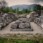
Ulpia Traiana Sarmizegetusa
Colonia Ulpia Traiana Augusta Dacica Sarmizegetusa was the capital and the largest city of Roman Dacia, later named Ulpia Traiana Sarmizegetusa after the former Dacian capital, located some 40 km away. Built on the ground of a camp of the Fifth Macedonian Legion, the city was populated with veterans of the Dacian wars. It received from the very beginning the title of colonia and the status of Ius Italicum. With an area of 30 ha and a population between 20.000 - 25.000 and strong fortifications, Ulpia Traiana was the political, administrative and religious centre of Dacia Romana, in the 2nd and 3rd centuries.
The exact period when the city was built is not known. Some say the first settlement was erected between 106-107, other say it was between 108-110. However, due to an inscription discovered at the beginning of the 14th century in the village of Gradiste, it is known that the settlement of the new town was done in the first years after the conquest of Dacia. The inscription reads: "On the command of the emperor Cesar Nerva Traianus Augustus, son of the divine Nerva, was settled the Dacian Colony by Decimus Terentius Scaurianus, its governor."
In Rome, the settlement of the colony was marked by the minting of a coin, at the Senate's order, dedicated to emperor Trajan.
During the reign of Hadrian the city was renamed Colonia Ulpia Traiana Augusta Dacica Sarmizegetusa. Between 222 - 235 the colony is called metropolis. The name was found on a stone inscription that reads "To Caius Arrius Quadratus, son of Gaius Arrius Antoninus, acting praetor of the emperor in colonia Ulpia Traiana Augusta Dacica Sarmizegetusa." Gaius Arrius Antoninus bore the title legatus pro praetore, which was the official title of the governor of some imperial provinces of the Roman Empire.
The settlement was built at a distance of 8 km from Tapae, a pass between Banat and Transylvania (today known as The Iron Gates of Transylvania). The choice was based on the military and economic advantages given by the natural barrier represented by the Retezat Mountains in the South and Poiana Ruscă Mountains in the North. The territory of the metropolis laid from Tibiscum to Micia and to the Jiu canyon, the city being protected by several castra: Tibiscum, Voislova, Micia şi Bumbeşti.
The city was crossed by the imperial road from Danube that marked the linked between the North of the province and Porolissum (Moigrad).


Informationen
| Sektion | Reise: Romania |
| Ordner | Travel |
| Views | 5.334 |
| Veröffentlicht | |
| Sprache |

|
| Lizenz |
Foto einbetten
Füge den folgenden Link in einem Kommentar, eine Beschreibung oder eine Nachricht ein, um dieses Bild darin anzuzeigen.
Link kopiert...
Klicke bitte auf den Link und verwende die Tastenkombination "Strg C" [Win] bzw. "Cmd C" [Mac] um den Link zu kopieren.
Im Messenger teilen
Füge den folgenden Link per 'Einfügen' in das Kommentarfeld der gewünschten Konversation im Messenger ein, um dieses Bild in der Nachricht zu versenden.
Link kopiert...
Klicke bitte auf den Link und verwende die Tastenkombination "Strg C" [Win] bzw. "Cmd C" [Mac] um den Link zu kopieren.
Kommentare 0
Kommentar löschen
Kommentar und Antworten löschen